
Circuit VTT 14 vert

Fiche technique
- Distance
- 27,9 km
- Montée
- +50 m
- Descente
- −50 m
- Durée estimée
- 2 h 05
- vtt
- Difficulté
- Très facile
- cotation officielle
- Parcours
- Boucle
- retour au départ
Profil et pente
- moins de 10 %
- 10 à 20 %
- plus de 20 %
Pente sur le parcours : 27,9 km à moins de 10 %. Altitude de 2 m à 37 m sur 27,9 km.
Difficulté
Cotation officielle : très facile, selon Communauté d'agglomération Royan Atlantique.
Accès
Départ : Saujon, Saujon (17).
Sources
- Trace : Communauté d'agglomération Royan Atlantique (CARA), Licence Ouverte 1.0, Licence Ouverte 1.0 (Etalab) (www.data.gouv.fr/datasets/apn-vtt-1). Durée estimée par GPX Path avec la règle de l'app Mac, hors pauses.
Traces voisines

 Plan IGN © IGN 2026
Circuit VTT 13 vert
Nouvelle-Aquitaine, Médis (17) · BoucleCotation officielle selon Communauté d'agglomération Royan Atlantique Plan IGN © IGN 2026
Circuit VTT 7 vert
Nouvelle-Aquitaine, Saint-Sulpice-de-Royan (17) · BoucleCotation officielle selon Communauté d'agglomération Royan Atlantique Plan IGN © IGN 2026
Circuit VTT 5 bleu
Nouvelle-Aquitaine, Breuillet (17) · BoucleCotation officielle selon Communauté d'agglomération Royan Atlantique Plan IGN © IGN 2026
Circuit VTT 10 bleu
Nouvelle-Aquitaine, Semussac (17) · BoucleCotation officielle selon Communauté d'agglomération Royan Atlantique Plan IGN © IGN 2026
Circuit VTT 2 vert
Nouvelle-Aquitaine, Chaillevette (17) · BoucleCotation officielle selon Communauté d'agglomération Royan Atlantique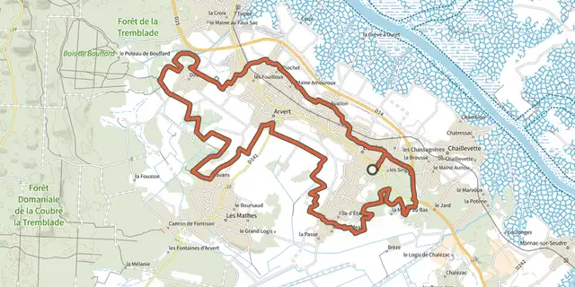 Plan IGN © IGN 2026
Circuit VTT 3 bleu
Nouvelle-Aquitaine, Étaules (17) · BoucleCotation officielle selon Communauté d'agglomération Royan Atlantique