
Grisou the Mule
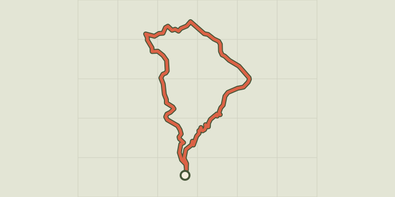
Key facts
- Distance
- 10.4 km
- Ascent
- +594 m
- Descent
- −482 m
- Estimated time
- 3 hr 20
- hiking
- Difficulty
- Moderate
- official rating
- Route
- Loop
- back to the start
Profile and gradient
- under 10%
- 10 to 20%
- over 20%
Gradient along the route: 7.0 km under 10%, 2.8 km at 10 to 20% and 0.5 km over 20%. Elevation from 425 m to 809 m over 10.4 km.
Description
Follow in the steps of Grisou, a sure-footed, one-eyed mule which criss-crossed the paths of this valley for 20 years! You will walk on old paths and explore the landscape cleverly fashioned by humans. Walk uphill alongside the road for 260 m. 1) Take the path on the right downhill to the river. Cross the bridge and go back up on a path with hairpin bends, which crosses a track three times. 2) After the chestnut orchard, take the track on the right to the road. 3) Cross the road and take the path which climbs above Le Valès to Les Ayres. 4) Turn left onto the D 54 to go through the village and, by the big chestnut trees, take the track on the left (the former draille or drovers’ road) to the Croix de Bourrel. 5) Shortly before the Croix de Bourrel, take the path on the left to join the road. Turn right onto the road. At the first intersection, turn right; at the second, turn left to walk through the hamlet of Saint-André de Lancize. 6) In the lower hamlet, take the grassy path through the gardens and meadows, then cross a ford, "le Gourg de la Vache". Continue on this path, cross a second ford, and walk uphill to join the road. 7) Turn left onto the road and, as you leave Le Viala, take on your right the small road that goes uphill to the hamlet of La Carrière. Go past the houses, stay on the track, join up again with the D 984 to reach Valmale. Go downhill on the road and take the track below the road, on the left, to return to your car.
Difficulty
Official rating: moderate, by Parc national des Cévennes.
Before you go
- NB. This walk is not recommended in wet weather (slippery rock and fords). Make sure your equipment is appropriate for the day’s weather conditions. Remember that the weather changes quickly in the mountains. Take enough water, wear sturdy shoes and put on a hat. Please close all gates and barriers behind you.
Getting there
Start: D 984 entre Saint-André de Lancize et Saint-Germain de Calberte, Saint-André-de-Lancize (48).
Sources
- Track: Parc national des Cévennes, Licence Ouverte 1.0, Licence Ouverte 1.0 (Etalab) (destination.cevennes-parcnational.fr/trek/44153-Le-mulet-Grisou). Time estimated by GPX Path with the Mac app rule, breaks not included.
- Official elevation gain: 594 m, Parc national des Cévennes
Nearby tracks

 © OpenStreetMap, SRTM · OpenTopoMap (CC-BY-SA)
The Rocks of Galta
Cévennes, Saint-Germain-de-Calberte (48) · LoopOfficial rating by Parc national des Cévennes © OpenStreetMap, SRTM · OpenTopoMap (CC-BY-SA)
Saint-Germain-de-Calberte
Cévennes, Saint-Germain-de-Calberte (48) · LoopOfficial rating by Parc national des Cévennes © OpenStreetMap, SRTM · OpenTopoMap (CC-BY-SA)
La Flandonenque
Cévennes, Saint-Germain-de-Calberte (48) · LoopOfficial rating by Parc national des Cévennes © OpenStreetMap, SRTM · OpenTopoMap (CC-BY-SA)
Le Gardonnet
Cévennes, Saint-Hilaire-de-Lavit (48) · LoopOfficial rating by Parc national des Cévennes © OpenStreetMap, SRTM · OpenTopoMap (CC-BY-SA)
Béal des Abrits
Cévennes, Saint-Martin-de-Lansuscle (48) · LoopOfficial rating by Parc national des Cévennes © OpenStreetMap, SRTM · OpenTopoMap (CC-BY-SA)
Castelviel
Cévennes, Saint-Martin-de-Lansuscle (48) · LoopOfficial rating by Parc national des Cévennes