
At the gateway to the Ecrins
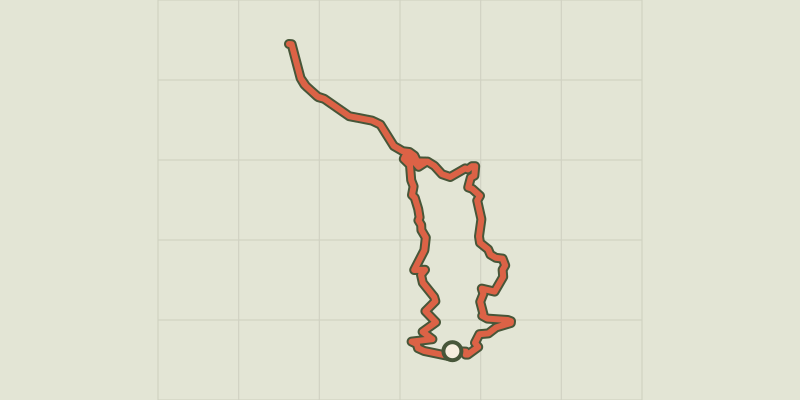
Key facts
- Distance
- 31.5 km
- Ascent
- +917 m
- Descent
- −856 m
- Estimated time
- 2 hr 35
- road cycling
- Difficulty
- Moderate
- official rating
- Route
- Loop
- back to the start
Profile and gradient
- under 10%
- 10 to 20%
- over 20%
Gradient along the route: 31.5 km under 10%. Elevation from 783 m to 1,472 m over 31.5 km.
Description
A goal of zero flats! A loop not to be embarked upon lightly, but one that is accessible to as many people as possible, thanks to the spread of electric assistance. The route stands out for the striking contrast between the lush pine forests and the rocky peaks of the Ecrins. You'll need to be well prepared at the start of the route to tackle the slopes of Puy-St-Eusèbe before arriving at the pretty village of Réallon and its 16th-century church. The ascent comes to an end at the foot of the Ecrins National Park. Quite a reward! - From the Centrale car park, come to a roundabout on the D41 and turn right towards Puy-Saint-Eusèbe (D641). After a 2.5 km climb, take the D741, still heading towards Puy-Saint-Eusèbe, and continue climbing. Cross the hamlet of Les Pins to Le Villard. - At the primary school, head towards Réallon along the D9. The view is unobstructed and offers a lovely vantage point over the Ecrins massif. The view is becoming increasingly interesting. Orgues (rock pillars), streams and marl follow one another in a wooded environment. Go past Les Méans and, at the next junction, turn right towards Réallon (D41). The landscape will not fail to impress. - Cross Réallon, observe the remains of an ancient fort and continue through the heart of this valley to reach the hamlet of Les Gourniers, at the gateway to the Ecrins National Park. The road ends here, so you will now have to turn around and go back to the D9/D41 junction. - Then turn right towards Savines-le-Lac. Pass Les Rousses and, at the next roundabout, follow the D41 towards Savines-le-Lac. Watch your speed on this beautiful descent, while enjoying the views over Serre-Ponçon Lake. Finally reach the valley by the railway line and return to the car park just after the roundabout.
Difficulty
Official rating: moderate, by Parc national des Écrins.
Getting there
Start: Parking de la Centrale, Savines-le-Lac (D41 au nord du lac), Savines-le-Lac (05).
Sources
- Track: Parc national des Écrins, Licence Ouverte 2.0, Licence Ouverte 2.0 (Etalab) (destination.ecrins-parcnational.fr/trek/996007-Aux-portes-des-Ecrins). Time estimated by GPX Path with the Mac app rule, breaks not included.
- Official elevation gain: 917 m, Parc national des Écrins
Nearby tracks

 © OpenStreetMap, SRTM · OpenTopoMap (CC-BY-SA)
Montée de Réallon depuis Savines-le-Lac
Écrins, Savines-le-Lac (05) · Point to pointOfficial rating by Parc national des Écrins © OpenStreetMap, SRTM · OpenTopoMap (CC-BY-SA)
Col de Pontis depuis Savines-le-Lac
Écrins, Savines-le-Lac (05) · Point to pointOfficial rating by Parc national des Écrins © OpenStreetMap, SRTM · OpenTopoMap (CC-BY-SA)
Les Trois Rivières
Écrins, Savines-le-Lac (05) · LoopOfficial rating by Parc national des Écrins © OpenStreetMap, SRTM · OpenTopoMap (CC-BY-SA)
Montée de la Draye
Écrins, Crots (05) · Point to pointOfficial rating by Parc national des Écrins © OpenStreetMap, SRTM · OpenTopoMap (CC-BY-SA)
Montée de Réallon depuis Chorges
Écrins, Chorges (05) · Point to pointOfficial rating by Parc national des Écrins © OpenStreetMap, SRTM · OpenTopoMap (CC-BY-SA)
Around Lake Serre-Ponçon
Écrins, Embrun (05) · LoopOfficial rating by Parc national des Écrins