
Traverse de l'échelle
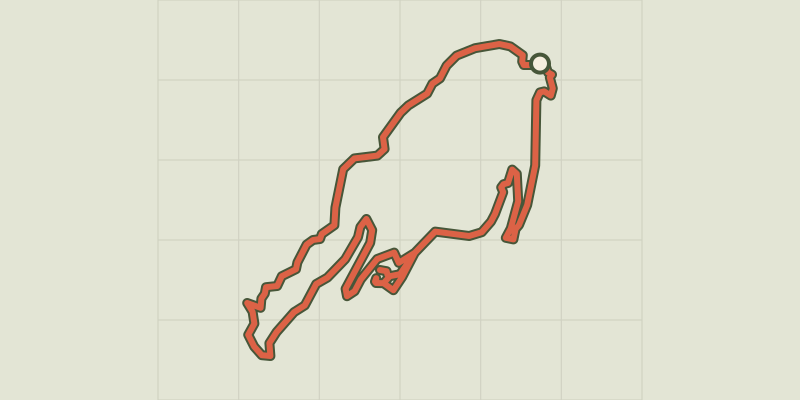
Key facts
- Distance
- 2.8 km
- Ascent
- +169 m
- Descent
- −134 m
- Estimated time
- 55 min
- hiking
- Difficulty
- Difficult
- official rating
- Route
- Loop
- back to the start
Profile and gradient
- under 10%
- 10 to 20%
- over 20%
Gradient along the route: 1.7 km under 10%, 0.6 km at 10 to 20% and 0.5 km over 20%. Elevation from 452 m to 529 m over 2.8 km.
Description
From the Luberon to the Durance, the Calavon river passes through many rocky sites, but none has reached the size of the gorges of Oppedette. Magical! The rough descent complemented with handrails to move from one ledge to another, leads to 150m below the deepest gorges. Then, following a riverside, the route rises abruptly on the opposite bank and escapes in the end by the pitch through the scale best climb with caution. An active discovery that requires crossing several air and technical passages on cliff edges, sometimes exposed despite the equipment. A real treat.! From the car park, go right of the two viewpoints (accessible to persons with disabilities), then take the small winding path that switches left in the gorges. A little further down, cross on the right a first jump using the handrail, and then continue the narrow path with caution. Pass along the last passage equipped with handrails land reach to the edge of a basin on the shores of Calavon. 1 - Turn left and continue advancing in the best possible way along the left bank. Cross a short rocky passage, then continue through the gorges until a more narrow passage. 2 - Cross the river ford (caution in case of flooding!) and locate across the entrance of the trail that goes back on the right bank opposite (pole). Continue slowly on steep slope, then at the top of the valley, go into the dark and damp pitch. Climb the ladder and go onto the sunny side. 3 - Turn left, walk past a viewpoint, and then continue on the cliff path. Go up a little, then cross a rocky path. Then go down between the cliff edge and a rock slide, to reach the upstream circus of the gorges. At the end of the beautiful cliff, hurtle down the switchbacks up to the river. 4 - Cross the ford of the Calavon (caution in case of flooding!), head across, then follow a stony path, reach the village at the top of the rocky outcrop. In front of the town hall, turn right, enter the heartof the village and take an alley on the left to reach the plateau. Leave the obvious wide path, take a right at the cemetery and follow the trail through the grass to emerge again at the base of the gorges. Turn left at the view point and reach the car park from the starting point.
Difficulty
Official rating: difficult, by Parcs naturels régionaux de Provence-Alpes-Côte d'Azur.
Before you go
- This itinerary is reserved for hikers who do not fear the void! To be avoided by all means during rainy or foggy weather.
- - A series of air and technical passages on cliff edges, sometimes exposed despite the existing equipment (handrails).
- - 2 fording sites; turn around in case of flooding!
- - Steep slope and ladder climbing (with railings).
- - Many inconvenient rocky passages (limestone pavement).
- Remember to bring enough water, especially in the hot sun!
Getting there
Start: Parking des belvédères, Oppedette, Oppedette (04).
Sources
- Track: Parcs naturels régionaux de Provence-Alpes-Côte d'Azur (Chemins des Parcs), Licence Ouverte 2.0, Licence Ouverte 2.0 (Etalab) (www.cheminsdesparcs.fr/trek/18380-OPPEDETTE---La-traverse-de-l-echelle). Time estimated by GPX Path with the Mac app rule, breaks not included.
- Official elevation gain: 169 m, Parcs naturels régionaux de Provence-Alpes-Côte d'Azur
Nearby tracks

 © OpenStreetMap, SRTM · OpenTopoMap (CC-BY-SA)
Tour of the Gorges d'Oppedette
Luberon, Oppedette (04) · LoopOfficial rating by Parcs naturels régionaux de Provence-Alpes-Côte d'Azur © OpenStreetMap, SRTM · OpenTopoMap (CC-BY-SA)
Viens - Saint-Amas et la dalle à empreintes
Luberon, Viens (84) · LoopOfficial rating by Parcs naturels régionaux de Provence-Alpes-Côte d'Azur © OpenStreetMap, SRTM · OpenTopoMap (CC-BY-SA)
Viens - Petit tour de Piégros
Luberon, Viens (84) · LoopOfficial rating by Parcs naturels régionaux de Provence-Alpes-Côte d'Azur © OpenStreetMap, SRTM · OpenTopoMap (CC-BY-SA)
The Provençal Colorado
Luberon, Rustrel (84) · LoopOfficial rating by Parcs naturels régionaux de Provence-Alpes-Côte d'Azur © OpenStreetMap, SRTM · OpenTopoMap (CC-BY-SA)
The Provençal Colorado
Luberon, Rustrel (84) · LoopOfficial rating by Parcs naturels régionaux de Provence-Alpes-Côte d'Azur © OpenStreetMap, SRTM · OpenTopoMap (CC-BY-SA)
Céreste - De La Gardette au Nid d'Amour
Luberon, Céreste-en-Luberon (04) · LoopOfficial rating by Parcs naturels régionaux de Provence-Alpes-Côte d'Azur