
Col de la Crèche
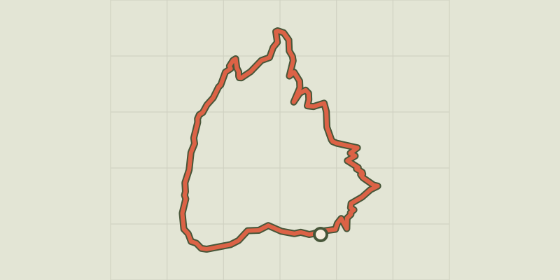
Key facts
- Distance
- 9.3 km
- Ascent
- +632 m
- Descent
- −610 m
- Estimated time
- 3 hr 40
- hiking
- Difficulty
- Moderate
- official rating
- Route
- Loop
- back to the start
Profile and gradient
- under 10%
- 10 to 20%
- over 20%
Gradient along the route: 3.5 km under 10%, 4.4 km at 10 to 20% and 1.4 km over 20%. Elevation from 1,683 m to 2,285 m over 9.3 km.
Description
A view of the whole valley of Guil, for a quick approach. The climb takes place in a forest rich in colour and sounds. Wrens, different chickadees, woodpeckers ... all sing their melodies and cheer up the atmosphere. Once at the mountain pass, the view is fascinating. It covers 180° from Ratier to the Italian border. At the north, the great Rochebrune guards the premises. The peak and its buttresses dominate the valley of Péas and enforce the respect on this valley where herds have been roaming since the dawn of time. Go to the end of the parking lot and follow the forest road to Rouet. Take the first track on the right (GR). Continue on the GR to the point Le Puy. 1 - at the oratory, turn left on the path that goes into the woods. Reach a track, turn right and follow it to the point "Platenq la Charpenelle" (1 900m). 2 - Turn left on a wide path that is rapidly shrinking and makes ascending switchbacks. Gradually emerge from the forest and reach a short portion (10m) a little more technical in shale that lead to the Col de Crèche. 3 - Turn right on a level, go around the great slump and turn left directly into the forest. 4 - Enter the pine forest and go down the switchbacks. Reach a wider path, turn right and quickly join the sheep pen of Péas. 5 - Take the left path that reaches Rouet. The trail follows the forest track, except on a short passage from a few metres down this track, and brings you back to the starting point.
Difficulty
Official rating: moderate, by Parcs naturels régionaux de Provence-Alpes-Côte d'Azur.
Getting there
Start: Les Meyriès, Château-Ville-Vieille (05).
Sources
- Track: Parcs naturels régionaux de Provence-Alpes-Côte d'Azur (Chemins des Parcs), Licence Ouverte 2.0, Licence Ouverte 2.0 (Etalab) (www.cheminsdesparcs.fr/trek/27431-CHATEAU-QUEYRAS---Col-de-la-Creche). Time estimated by GPX Path with the Mac app rule, breaks not included.
- Official elevation gain: 632 m, Parcs naturels régionaux de Provence-Alpes-Côte d'Azur
Nearby tracks
 © OpenStreetMap, SRTM · OpenTopoMap (CC-BY-SA)
Sentier écologique des Astragales - Ville-Vieille
Queyras, Château-Ville-Vieille (05) · LoopOfficial rating by Parcs naturels régionaux de Provence-Alpes-Côte d'Azur © OpenStreetMap, SRTM · OpenTopoMap (CC-BY-SA)
Arvieux - La Saga de l'herbe
Queyras, Arvieux (05) · LoopOfficial rating by Parcs naturels régionaux de Provence-Alpes-Côte d'Azur © OpenStreetMap, SRTM · OpenTopoMap (CC-BY-SA)
Arvieux - Belvédères du lac de Roue
Queyras, Arvieux (05) · LoopOfficial rating by Parcs naturels régionaux de Provence-Alpes-Côte d'Azur © OpenStreetMap, SRTM · OpenTopoMap (CC-BY-SA)
Sentier de découverte des Fourmis - Aiguilles
Queyras, Aiguilles (05) · Out and backOfficial rating by Parcs naturels régionaux de Provence-Alpes-Côte d'Azur © OpenStreetMap, SRTM · OpenTopoMap (CC-BY-SA)
Molines - Le long des Aigues
Queyras, Molines-en-Queyras (05) · Out and backOfficial rating by Parcs naturels régionaux de Provence-Alpes-Côte d'Azur © OpenStreetMap, SRTM · OpenTopoMap (CC-BY-SA)
Sommet Bucher
Queyras, Molines-en-Queyras (05) · LoopOfficial rating by Parcs naturels régionaux de Provence-Alpes-Côte d'Azur