
Pigeon huts and ATV cabins
Key facts
- Distance
- 21.5 km
- Ascent
- +428 m
- Descent
- −356 m
- Estimated time
- 2 hr 15
- mtb
- Difficulty
- Difficult
- official rating
- Route
- Loop
- back to the start
Profile and gradient
- under 10%
- 10 to 20%
- over 20%
Gradient along the route: 20.0 km under 10% and 1.5 km at 10 to 20%. Elevation from 520 m to 693 m over 21.5 km.
Description
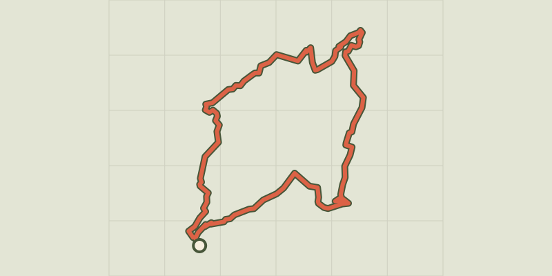
Path making... A bicycle from one shed to another A silhouetted hut on the plateau of Valensole, a pastoral hut in the shade of a slope, a fountain on a village square are all links that the territory maintains with those who have lived there or who live there on a daily basis. The paths leading to them become again pathways of life which invite everyone to adapt their step, or their turn of the wheel to better discover and feel the many facets of the Verdon. From Riez, take a small communal road and climb up the plateau; the climb is arduous but promises a striking view of the Verdon mountains. Find a trail that is at first brittle and steep and increasingly rolling. Travel between truffle and lavender to the village of Puimoisson. Go down the plateau by the Moustiers road, between rolling trails and small secondary roads, then follow the Colostre (ford, potentially flooded, caution! possibility of variant while staying on the road) in the direction of Roumoules. Exit Roumoules by the GR4 and, after a few hundred meters, climb up the plateau via a steep and stony path (bifurcation loop 2). Amore accessible variant takes you through the trading estate. There is a straight and rolling trail completely open on the fields of lavender and olive trees that join the chapel of Sainte-Maxime. Take a last stony descent (variant possible by road) until the heart of the picturesque lanes of Riez.
Difficulty
Official rating: difficult, by Parcs naturels régionaux de Provence-Alpes-Côte d'Azur.
Before you go
- On the roads, follow the rules and be careful at intersections. - Do not attempt to enter the huts, they are private property! Be careful as you approach, some cabins can be dangerous (falling stones, snakes, & hellip;) - Be careful in the hot summer temperatures: take plenty of water and a picnic. Make sure you have all the necessary accessories/equipment for a good hike: helmets, repair tools, air pump, anti-theft, maps, sunscreen.
Getting there
Start: Riez, Riez (04).
Sources
- Track: Parcs naturels régionaux de Provence-Alpes-Côte d'Azur (Chemins des Parcs), Licence Ouverte 2.0, Licence Ouverte 2.0 (Etalab) (www.cheminsdesparcs.fr/trek/20093-RIEZ---Les-Pigeonniers-et-Cabanons-a-VTT). Time estimated by GPX Path with the Mac app rule, breaks not included.
- Official elevation gain: 428 m, Parcs naturels régionaux de Provence-Alpes-Côte d'Azur
Nearby tracks
 © OpenStreetMap, SRTM · OpenTopoMap (CC-BY-SA)
Mountain Biking Plateau Cabins
Verdon, Puimoisson (04) · LoopOfficial rating by Parcs naturels régionaux de Provence-Alpes-Côte d'Azur © OpenStreetMap, SRTM · OpenTopoMap (CC-BY-SA)
Moustiers-Sainte-Marie - Jusqu’aux plages du lac de Sainte-Croix à VTT
Verdon, Moustiers-Sainte-Marie (04) · Out and backOfficial rating by Parcs naturels régionaux de Provence-Alpes-Côte d'Azur © OpenStreetMap, SRTM · OpenTopoMap (CC-BY-SA)
Saint-André-les-Alpes - Le Chalvet à VTT
Verdon, Saint-André-les-Alpes (04) · LoopOfficial rating by Parcs naturels régionaux de Provence-Alpes-Côte d'Azur
 © OpenStreetMap, SRTM · OpenTopoMap (CC-BY-SA)
La Chapelle Saint-Maxime
Verdon, Riez (04) · LoopOfficial rating by Parcs naturels régionaux de Provence-Alpes-Côte d'Azur © OpenStreetMap, SRTM · OpenTopoMap (CC-BY-SA)
The Millarettes plateau
Verdon, Riez (04) · LoopOfficial rating by Parcs naturels régionaux de Provence-Alpes-Côte d'Azur © OpenStreetMap, SRTM · OpenTopoMap (CC-BY-SA)
Montagnac - MONTPEZAT - Le circuit des deux oratoires
Verdon, Montagnac-Montpezat (04) · LoopOfficial rating by Parcs naturels régionaux de Provence-Alpes-Côte d'Azur