
The peak of the Lachens Mountain
Key facts
- Distance
- 9.1 km
- Ascent
- +710 m
- Descent
- −682 m
- Estimated time
- 4 hr
- hiking
- Difficulty
- Difficult
- official rating
- Route
- Out and back
- same way back
Profile and gradient
- under 10%
- 10 to 20%
- over 20%
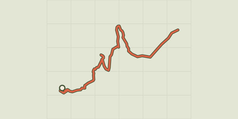
Gradient along the route: 3.0 km under 10%, 3.7 km at 10 to 20% and 2.5 km over 20%. Elevation from 981 m to 1,658 m over 9.1 km.
Description
Conquering the highest peak in the Var the Lachens mountain With its ruined Castrum of Sainte-Madeleine and panoramas of endless views. This athletic trek will make you want to reach for the sky while taking you to heights allowing you to contemplate exceptional panoramas. On this route you will see the pine forests, the flora of Haute-Provence and perhaps at the top, sheep herds grazing. At the top of Mount Lachens, Var's highest peak (1 715m); panoramic views of the Mediterranean Sea to the Alps. You will find a viewpoint allowing you to identify the main peaks of Provence. From the church square, go up the lane "Chemin de l'Aire" by following the markings of the GR49 (white and red marking). To the top of the village, at the end of the paved section, at 300m. 1 - Leave the GR and follow the path going left towards the top of Mount Lachens. Walk on the shaded path (light blue marking of the local RP), along the stone walls to the clearing. Leave it on the right and continue up the main road on the left towards the Ste-Madeleine rock (steep climb!). Quickly take the well-marked trail under the pine trees and exit the woods a little before the rock. Walk again under the pine trees and at a crossroads, reach the route leading to the top of Mount Lachens. 2 - Do not take the trail leading to the ruins of the castle (300m round trip) on the left and continue on the route marked in blue on the right. The winding trail rises above the plain of the Bruyère then rapidly goes into the woods, among boxwood, brooms (plants) and scots pines, until reaching a track (some steep sections!). Continue on this track 500m after passing a collar and just before a corner, take the poorly outlined path marked in blue, going up on the right. Reach further up the path leading to the peak of Mount Lachens 3 - Follow the road (white and red markings). Pass over a picnic area in front of a tank and take the path cutting the corner. Cross the road and continue up the path. Near the forest, continue the route on the ridge of Mount Lachens amid pastures and limestone pavements. Follow the ridge to the viewpoint. 4 - The tour ends at the top located at 1 685m, just opposite the peak of Mount Lachens (1 715m). The same route is used for the return.
Difficulty
Official rating: difficult, by Parcs naturels régionaux de Provence-Alpes-Côte d'Azur.
Before you go
- Eviter les fortes chaleurs estivales, partir tôt. Prévoir : 2L d’eau par personne, un chapeau et des chaussures de randonnée. Saisons privilégiées : été, printemps, automne. Ne dérangez pas les moutons habitués à la tranquillité de ces montagnes.
Getting there
Start: Place de l'église, La Bastide, La Bastide (83).
Sources
- Track: Parcs naturels régionaux de Provence-Alpes-Côte d'Azur (Chemins des Parcs), Licence Ouverte 2.0, Licence Ouverte 2.0 (Etalab) (www.cheminsdesparcs.fr/trek/17430-LA-BASTIDE---Sommet-de-Lachens). Time estimated by GPX Path with the Mac app rule, breaks not included.
- Official elevation gain: 710 m, Parcs naturels régionaux de Provence-Alpes-Côte d'Azur
Nearby tracks

 © OpenStreetMap, SRTM · OpenTopoMap (CC-BY-SA)
La Martre - L'Avelanier
Verdon, La Martre (83) · LoopOfficial rating by Parcs naturels régionaux de Provence-Alpes-Côte d'Azur © OpenStreetMap, SRTM · OpenTopoMap (CC-BY-SA)
Le chemin de Napoléon
Verdon, La Martre (83) · Out and backOfficial rating by Parcs naturels régionaux de Provence-Alpes-Côte d'Azur © OpenStreetMap, SRTM · OpenTopoMap (CC-BY-SA)
Tour de l'Artuby - 5 par Le Logis du Pin
Verdon, La Martre (83) · Point to pointOfficial rating by Parcs naturels régionaux de Provence-Alpes-Côte d'Azur © OpenStreetMap, SRTM · OpenTopoMap (CC-BY-SA)
Chateauvieux - La boucle Chateauvieux - La Martre
Verdon, Châteauvieux (83) · LoopOfficial rating by Parcs naturels régionaux de Provence-Alpes-Côte d'Azur © OpenStreetMap, SRTM · OpenTopoMap (CC-BY-SA)
Brenon - Le sommet de Clare
Verdon, Brenon (83) · LoopOfficial rating by Parcs naturels régionaux de Provence-Alpes-Côte d'Azur © OpenStreetMap, SRTM · OpenTopoMap (CC-BY-SA)
A round-trip to Peyroules
Verdon, Peyroules (04) · LoopOfficial rating by Parcs naturels régionaux de Provence-Alpes-Côte d'Azur