
Lac Gary via le Vet
Key facts
- Distance
- 16.2 km
- Ascent
- +1,941 m
- Descent
- −1,891 m
- Estimated time
- 9 hr 55
- hiking
- Difficulty
- Difficult
- official rating
- Route
- Out and back
- same way back
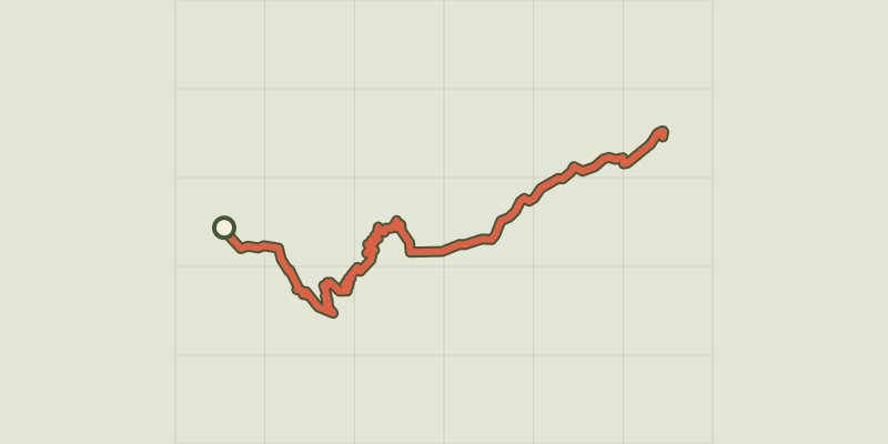
Profile and gradient
- under 10%
- 10 to 20%
- over 20%
Gradient along the route: 1.6 km under 10%, 4.1 km at 10 to 20% and 10.6 km over 20%. Elevation from 807 m to 2,467 m over 16.2 km.
Description
This signposted itinerary is the only one that enables you to reach the magnificent Gary Lake in the Arcanier massif that resembles a citadel. The path starts from the lowest point of the heart of the National Park at an altitude of 800 m. This long, demanding hike will take you across all alpine vegetation stages. The ascension along the Tête de Vêt and via the Gary Gap offer panoramic views of a good part of the Ecrins, Devoluy, Vercors et Grand Armet. From the Entraigues church car park, follow the road to Valjouffrey up to the last garden and turn left onto the footpath that is signposted Vet-lac- Gary. It continues along a stream that starts at the Combe de la Draye, then climbs up across a rock fall and meanders along rocky ledges. The footpath goes through a beech forest and continues swiftly upwards as it gets closer to the Combe des Roberts, which it crosses as it continues to gain in altitude on the right bank. At the fork in the road Jas des Agneaux/Vet-Lac Gary hut, the slope is not so steep. Follow the route on the right hand side and, by the ledge footpath, enter the Vêt valley in order to get to the pastoral hut. The route follows the left bank of the stream. Link up to the small path coming from Drayes on the Blanc pass. It meanders on a slope of scree below the gap in the Arcanier. From the Gary gap, go down as far as the lake that is set on a terrace facing the summit of the Valjouffrey valley. Return by the same route.
Difficulty
Official rating: difficult, by Parc national des Écrins.
Before you go
- There is no water supply!
Getting there
Start: Entraigues, Entraigues (38).
Sources
- Track: Parc national des Écrins, Licence Ouverte 2.0, Licence Ouverte 2.0 (Etalab) (destination.ecrins-parcnational.fr/trek/903953-Le-lac-Gary-par-le-Vet). Time estimated by GPX Path with the Mac app rule, breaks not included.
- Official elevation gain: 1,941 m, Parc national des Écrins
Nearby tracks
 © OpenStreetMap, SRTM · OpenTopoMap (CC-BY-SA)
The jas des Agneaux by the Combe des Roberts
Écrins, Entraigues (38) · Out and backOfficial rating by Parc national des Écrins © OpenStreetMap, SRTM · OpenTopoMap (CC-BY-SA)
Jas des Agneaux via Pissard des Aiguilles
Écrins, Chantepérier (38) · Out and backOfficial rating by Parc national des Écrins © OpenStreetMap, SRTM · OpenTopoMap (CC-BY-SA)
Touret Rock
Écrins, Chantepérier (38) · Out and backOfficial rating by Parc national des Écrins © OpenStreetMap, SRTM · OpenTopoMap (CC-BY-SA)
La cabane de Rif Meyol
Écrins, Chantepérier (38) · Out and backOfficial rating by Parc national des Écrins © OpenStreetMap, SRTM · OpenTopoMap (CC-BY-SA)
Tour of Pic de Valsenestre
Écrins, Valjouffrey (38) · Point to pointOfficial rating by Parc national des Écrins © OpenStreetMap, SRTM · OpenTopoMap (CC-BY-SA)
La Chalp valley
Écrins, Valjouffrey (38) · Out and backOfficial rating by Parc national des Écrins