
Maxi Goureng (trail route no. 14)
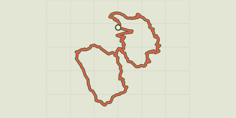
Key facts
- Distance
- 32.0 km
- Ascent
- +2,335 m
- Descent
- −2,197 m
- Estimated time
- 5 hr 25
- trail running
- Difficulty
- Difficult
- official rating
- Route
- Loop
- back to the start
Profile and gradient
- under 10%
- 10 to 20%
- over 20%
Gradient along the route: 11.0 km under 10%, 17.0 km at 10 to 20% and 4.0 km over 20%. Elevation from 1,118 m to 2,497 m over 32.0 km.
Description
A full and wild trail gradually leading to small valleys perched so far from the valley &hellip “ Descending from the Col de Val Haute into the secret valley of Font Cailla, under the cliffs of the Tête de Gaulent, is a thrilling moment. Here, you are only likely to meet a shepherd and his flock, depending on the season. ” Marie-Geneviève Nicolas, park ranger at the Parc National des Écrins Go up through the village of Freissinières following signs for Les Roberts and Les Aujards. Then continue on the path leading to Le Clot du Puy and the Col de l'Aiguille. A steep descent brings you back to the hamlet of Pallon. - Cross the bridge over the Biaysse and go up a lane opposite, which will turn into a track. - At the hamlet of Le Serre, turn left between two houses onto the path leading to Les Seyes. From this hamlet, head towards Clot Lafont. The path rises for a long stretch through the forest and, after a steeper section, comes out into the alpine pasture of Clot Lafont. Carry on until you come to the Col de Tramouillon. Head downhill towards the Cabane de Tramouillon. - Make a there-and-back detour to visit the cabin. - Take a path on the left which passes close to the Cabane de l'Essaumaure. Climb uphill again until you come to the Col de Val Haute. Drop down through the valley of Font Cailla and take a path leading away across the hillside to join the farm track to Le Lauzet. Follow this path along a long traverse and then follow the downhill track to the park cabin ("Cabane du Parc") and Freissinières (paths cutting across the sharp bends) which brings you back to the valley bottom. You reach Freissinières via a track running along the right-hand bank of the Biaysse.
Difficulty
Official rating: difficult, by Parc national des Écrins.
Before you go
- Before setting off, it is very important to check the opening periods for this route on the website: https://stationdetrail.com/fr/stations/le-pays-des-ecrins/parcours
- Share your photographs on social networks with #stationdetrailecrins
- Check weather conditions before setting off.
- Rescue services contact details: Secours Montagne (Mountain Rescue): +33 (0)4 92 22 22 22 or 112
- Show consideration for the work of farmers, livestock keepers and owners
- Close all gates behind you
- Take your litter home
- Do not take shortcuts across pastureland
- The trail routes are also suitable for walking
Getting there
Start: Maison de la Vallée, Freissinières, Freissinières (05).
Sources
- Track: Parc national des Écrins, Licence Ouverte 2.0, Licence Ouverte 2.0 (Etalab) (destination.ecrins-parcnational.fr/trek/959540-Trail-N14---Maxi-Goureng). Time estimated by GPX Path with the Mac app rule, breaks not included.
- Official elevation gain: 2,335 m, Parc national des Écrins
Nearby tracks

 © OpenStreetMap, SRTM · OpenTopoMap (CC-BY-SA)
La Balade de Monsieur - Gentleman's Trail (trail route no. 2)
Écrins, Freissinières (05) · LoopOfficial rating by Parc national des Écrins © OpenStreetMap, SRTM · OpenTopoMap (CC-BY-SA)
Our ancestors, those trail runners (trail route no. 6)
Écrins, Freissinières (05) · LoopOfficial rating by Parc national des Écrins © OpenStreetMap, SRTM · OpenTopoMap (CC-BY-SA)
Rortie Bleue (trail route no. 7)
Écrins, Freissinières (05) · LoopOfficial rating by Parc national des Écrins © OpenStreetMap, SRTM · OpenTopoMap (CC-BY-SA)
Kilomètre Vertical - Freissinières
Écrins, Freissinières (05) · Out and backOfficial rating by Parc national des Écrins © OpenStreetMap, SRTM · OpenTopoMap (CC-BY-SA)
Entrainement - Boucle Longue - Freissinières
Écrins, Freissinières (05) · LoopOfficial rating by Parc national des Écrins © OpenStreetMap, SRTM · OpenTopoMap (CC-BY-SA)
Around the mines (trail route no. 22)
Écrins, L'Argentière-la-Bessée (05) · LoopOfficial rating by Parc national des Écrins