
Tour de l'Aiguille de Vénosc
Key facts
- Distance
- 20.5 km
- Ascent
- +1,939 m
- Descent
- −1,918 m
- Estimated time
- 10 hr 30
- hiking
- Difficulty
- Difficult
- official rating
- Route
- Point to point
- ends elsewhere
Profile and gradient
- under 10%
- 10 to 20%
- over 20%
Gradient along the route: 5.5 km under 10%, 5.0 km at 10 to 20% and 10.0 km over 20%. Elevation from 851 m to 2,516 m over 20.5 km.
Description
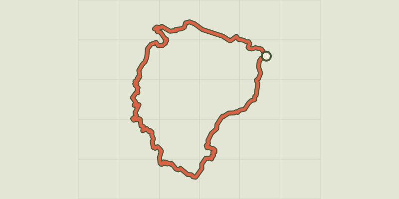
A nice circuit passing from lake to lake, leading you up to the high mountains in 2 days, with the bonus of a breathtaking and original view over the Barre des Ecrins, the only mountains over 4000 m in the southern Alps (4102m). A subtle blend, with bucolic views succeeded by an Alpine refuge on the lakeside, with a glacier looking down, and then the austere panorama of rock and ice of the valley col. Not to mention the pride of completing parts of the famous GR®54 and the privilege of seeing the total reserve of Lauvitel and its impressive mountain lake from above. After walking up the little narrow street towards the upper part of the village of Alleau, the climb begins on a fine forest path that then passes above the left bank of the Pisse torrent. The ascent is continuous, but the slope finally flattens out and you arrive at the magnificent corrie of Lake Muzelle with its refuge elegantly placed just above the lake. Both are watched over from above by the Muzelle glacier. After a restful night at the refuge, you start up a fairly steep path that zigzags its way just under the valley pass. Here, take your time to admire the Barre des Ecrins from an uncommon angle. Soon afterwards, the descent looks down almost continually on Lake Lauvitel, with sections that are sometimes fitted with handrails. After Lauvitel “beach” and its pile of stone blocks, the descent towards La Danchère passes along a path that is almost entirely paved and that can get quite crowded. You then return to the village of L’Alleau partly alongside the powerful River Vénéon, in peace and quiet, through the forest.
Difficulty
Official rating: difficult, by Parc national des Écrins.
Before you go
- The best period for this tour is from mid-June to the end of September, when the Muzelle refuge is open. Ask about weather and snow levels in the col valley in early summer. Some sections in the descent towards Lauvitel have handrails and can be tricky in wet weather. The same goes for the paved paths in the descent after Lake Lauvitel, which can sometimes be slippery.
Getting there
Start: Le Bourg d'Arud, Les Deux Alpes (38).
Sources
- Track: Parc national des Écrins, Licence Ouverte 2.0, Licence Ouverte 2.0 (Etalab) (destination.ecrins-parcnational.fr/trek/956800-Tour-de-l-Aiguille-de-Venosc). Time estimated by GPX Path with the Mac app rule, breaks not included.
- Official elevation gain: 1,939 m, Parc national des Écrins
Nearby tracks

 © OpenStreetMap, SRTM · OpenTopoMap (CC-BY-SA)
Muzelle Lake
Écrins, Les Deux Alpes (38) · Out and backOfficial rating by Parc national des Écrins © OpenStreetMap, SRTM · OpenTopoMap (CC-BY-SA)
The Muzelle et Le Lauvitel lakes
Écrins, Les Deux Alpes (38) · LoopOfficial rating by Parc national des Écrins © OpenStreetMap, SRTM · OpenTopoMap (CC-BY-SA)
Tour Gourmand
Écrins, Les Deux Alpes (38) · Point to pointOfficial rating by Parc national des Écrins © OpenStreetMap, SRTM · OpenTopoMap (CC-BY-SA)
Le vallon de Lanchâtra
Écrins, Saint-Christophe-en-Oisans (38) · Out and backOfficial rating by Parc national des Écrins © OpenStreetMap, SRTM · OpenTopoMap (CC-BY-SA)
Plan Vianney lake and the Périer gap
Écrins, Les Deux Alpes (38) · Out and backOfficial rating by Parc national des Écrins © OpenStreetMap, SRTM · OpenTopoMap (CC-BY-SA)
Lauvitel Lake
Écrins, Les Deux Alpes (38) · LoopOfficial rating by Parc national des Écrins