
The hamlets of Les Orres

Key facts
- Distance
- 8.7 km
- Ascent
- +227 m
- Descent
- −182 m
- Estimated time
- 35 min
- road cycling
- Difficulty
- Very easy
- official rating
- Route
- Loop
- back to the start
Profile and gradient
- under 10%
- 10 to 20%
- over 20%
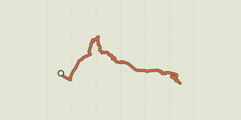
Gradient along the route: 8.2 km under 10% and 0.4 km at 10 to 20%. Elevation from 1,300 m to 1,459 m over 8.7 km.
Description
An idyllic journey! In the heart of the mountains, here you can enjoy a peaceful and charming setting, a chance to get away from it all in the heart of nature. A true promontory overlooking the Serre-Ponçon valley, the main town of Les Orres boasts a setting that can only be described as grandiose, with larch forests and steep peaks. This bike ride is perfect for those who want to explore the area with their family. It's sure to make for some great memories! - The start is in the centre of Les Orres. From the village, take the D140 towards Embrun, where a short descent brings you to the D40. Turn right. - Follow the D40 downhill until you reach a crossroads, shortly after a hairpin bend. From here, take the road on the left towards Le Pont and then Le Mélézet (D540). - The road takes a long crossing to reach the village of Le Mélézet from where you can gaze upon the scenery over the mountains. Keep heading in the direction of Embrun and rejoin the D40. - Continue on this departmental road, pass a hairpin bend and then, 1 km further on, turn right to reach the centre of Les Orres.
Difficulty
Official rating: very easy, by Parc national des Écrins.
Getting there
Start: Les Orres, Chef Lieu, Les Orres (05).
Sources
- Track: Parc national des Écrins, Licence Ouverte 2.0, Licence Ouverte 2.0 (Etalab) (destination.ecrins-parcnational.fr/trek/996002-Les-hameaux-des-Orres). Time estimated by GPX Path with the Mac app rule, breaks not included.
- Official elevation gain: 227 m, Parc national des Écrins
Nearby tracks
 © OpenStreetMap, SRTM · OpenTopoMap (CC-BY-SA)
Montée de Crévoux
Provence-Alpes-Côte d'Azur, Baratier (05) · Point to pointOfficial rating by Parc national des Écrins © OpenStreetMap, SRTM · OpenTopoMap (CC-BY-SA)
Montée des Orres
Provence-Alpes-Côte d'Azur, Baratier (05) · Point to pointOfficial rating by Parc national des Écrins © OpenStreetMap, SRTM · OpenTopoMap (CC-BY-SA)
Montée de la Draye
Écrins, Crots (05) · Point to pointOfficial rating by Parc national des Écrins © OpenStreetMap, SRTM · OpenTopoMap (CC-BY-SA)
Around Lake Serre-Ponçon
Écrins, Embrun (05) · LoopOfficial rating by Parc national des Écrins © OpenStreetMap, SRTM · OpenTopoMap (CC-BY-SA)
Right bank Serre-Ponçon
Écrins, Embrun (05) · LoopOfficial rating by Parc national des Écrins © OpenStreetMap, SRTM · OpenTopoMap (CC-BY-SA)
From one bank of the Durance to the other
Écrins, Embrun (05) · LoopOfficial rating by Parc national des Écrins