
Banne
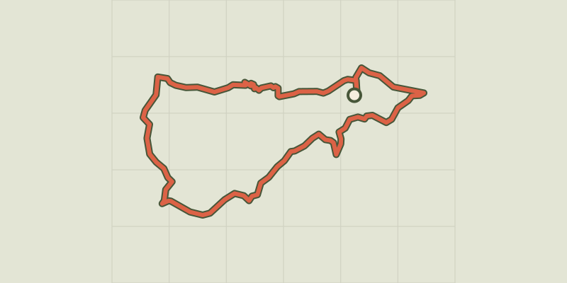
Key facts
- Distance
- 6.1 km
- Ascent
- +249 m
- Descent
- −215 m
- Estimated time
- 1 hr 50
- hiking
- Difficulty
- Moderate
- official rating
- Route
- Loop
- back to the start
Profile and gradient
- under 10%
- 10 to 20%
- over 20%
Gradient along the route: 4.4 km under 10%, 1.5 km at 10 to 20% and 0.2 km over 20%. Elevation from 204 m to 419 m over 6.1 km.
Description
A very shady walk with handsome views onto the plain, the Serre de Barre summit and the Cévennes. The Orcières geological faultline on this route gives the scenery a striking contrast. The juxtaposition of limestone and sandstone along the fault explains the differences in relief and vegetation that you will see as you walk from Banne to Le Mazel. Signposts will guide you all along this route. In the description below, the signposted place names and/or directions are given in bold italics between quotation marks : From the car park at the point information tourism walk to : - “Place de l’école”, then follow “Place du Fort 0,2 km”. - From “Place du Fort”, go to “Place de l'Eglise” via “Le Ranquet 1,1 km” (PR) - From the signpost for “Cimetière”, follow “Place de l'Eglise 0,2 km” (PR). - From “Place de l'Eglise”, continue to “Montgros” via “l'Ozide 2 km”. The path goes uphill between two low walls into an old chestnut grove, now partly taken over by maritime pines. At the cross, go left to an intersection of three tracks. - At “Montgros”, walk to “Le Mazel 1 km” (GR). Take the path on the right that starts near the concrete electricity pylon. 250 m further on, turn left then continue straight. The path goes downhill to a small road. Turn right onto it to reach the hamlet of Le Mazel. - At “Le Mazel”, follow “Place de l'Ecole 1,8 km” (GR, PR) to return to the car park that you started from.
Difficulty
Official rating: moderate, by Parc national des Cévennes.
Before you go
- Make sure your equipment is appropriate for the day’s weather conditions. Remember that the weather changes quickly in the mountains. Take enough water, wear sturdy shoes and put on a hat. Please close any gates and barriers behind you.
Getting there
Start: Banne, Banne (07).
Sources
- Track: Parc national des Cévennes, Licence Ouverte 1.0, Licence Ouverte 1.0 (Etalab) (destination.cevennes-parcnational.fr/trek/96978-Banne). Time estimated by GPX Path with the Mac app rule, breaks not included.
- Official elevation gain: 249 m, Parc national des Cévennes
Nearby tracks
 © OpenStreetMap, SRTM · OpenTopoMap (CC-BY-SA)
The wash houses (north)
Cévennes, Saint-Paul-le-Jeune (07) · LoopOfficial rating by Parc national des Cévennes © OpenStreetMap, SRTM · OpenTopoMap (CC-BY-SA)
The wash houses (south)
Cévennes, Saint-Paul-le-Jeune (07) · LoopOfficial rating by Parc national des Cévennes © OpenStreetMap, SRTM · OpenTopoMap (CC-BY-SA)
The cliff walk
Cévennes, Berrias-et-Casteljau (07) · LoopOfficial rating by Parc national des Cévennes © OpenStreetMap, SRTM · OpenTopoMap (CC-BY-SA)
The fox’s cave
Cévennes, Berrias-et-Casteljau (07) · LoopOfficial rating by Parc national des Cévennes © OpenStreetMap, SRTM · OpenTopoMap (CC-BY-SA)
Sentier de découverte de la Cocalière
Cévennes, Courry (30) · Out and backOfficial rating by Parc national des Cévennes © OpenStreetMap, SRTM · OpenTopoMap (CC-BY-SA)
Viaduct of Doulovy
Cévennes, Gagnières (30) · LoopOfficial rating by Parc national des Cévennes