
Cycling from Crau to the Vigueirat marshes.
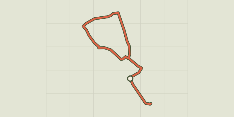
Key facts
- Distance
- 27.9 km
- Ascent
- +30 m
- Descent
- −12 m
- Estimated time
- 1 hr 10
- road cycling
- Difficulty
- Very easy
- official rating
- Route
- Loop
- back to the start
Profile and gradient
- under 10%
- 10 to 20%
- over 20%
Gradient along the route: 27.9 km under 10%. Elevation from 2 m to 14 m over 27.9 km.
Description
Discover the Crau and its exceptional steppe From the village of Mas-Thibert, this loop is a good introduction to discover the natural heritage of the Crau lowland. It is not uncommon to see near or near the horses and bulls of Camargue but also sheep. The smell of Crau hay and the lapping water of the Vigueirat canal will accompany you during your journey. To end this pleasant hike, it will be the bee-eaters, during the summer season, that will escort you to the Vigueirat Marshes. Back to the stadium, head to the right. At the intersection with the D24, turn right. Cross the canal du Vigueirat then 1.5 km after, go left on the C66 towards Raphèle-les-Arles. Continue for about 6.5 km. 1 - At the junction, turn to the left and take the path of the Canons (C64). Continue for about 4 km, past Tapie Saint-Léger and Le Mas de l'Hoste. 2 - At the intersection with the path of the Pont Calada (C65), head to the left. Continue for 2.5 km. 3 - At the Vigueirat Canal, take the dirt road C67 Volpeliere, take to the left. Walk along the canal for 3.5 km. 4 - At the junction with the C66, turn right to join Mas-Thibert on the same route as to go back to the Mas-Thibert stadium. 5 - From the Mas-Thibert stadium, continue on Avenue Alain Guigue, follow the signs "Marais du Vigueirat" by the bike path then the dirt road. Continue on the Etourneau path (C71). Take the opposite way to return to Mas-Thibert stadium.
Difficulty
Official rating: very easy, by Parcs naturels régionaux de Provence-Alpes-Côte d'Azur.
Before you go
- On the D24, caution, dangerous road! Respect the rules of the road on roads open to public traffic.
Getting there
Start: Stade Alain Guigue, Mas-Thibert (Arles), Arles (13).
Sources
- Track: Parcs naturels régionaux de Provence-Alpes-Côte d'Azur (Chemins des Parcs), Licence Ouverte 2.0, Licence Ouverte 2.0 (Etalab) (www.cheminsdesparcs.fr/trek/59373-ARLES---De-la-Crau-aux-Marais-du-Vigueirat-a-velo). Time estimated by GPX Path with the Mac app rule, breaks not included.
- Official elevation gain: 30 m, Parcs naturels régionaux de Provence-Alpes-Côte d'Azur
Nearby tracks

 © OpenStreetMap, SRTM · OpenTopoMap (CC-BY-SA)
Rice bike ride and Camargue horses
Provence-Alpes-Côte d'Azur, Arles (13) · LoopOfficial rating by Parcs naturels régionaux de Provence-Alpes-Côte d'Azur © OpenStreetMap, SRTM · OpenTopoMap (CC-BY-SA)
Cycling along the ViaRhôna
Provence-Alpes-Côte d'Azur, Arles (13) · Point to pointOfficial rating by Parcs naturels régionaux de Provence-Alpes-Côte d'Azur © OpenStreetMap, SRTM · OpenTopoMap (CC-BY-SA)
Discovering Vaccarès by bike
Provence-Alpes-Côte d'Azur, Arles (13) · LoopOfficial rating by Parcs naturels régionaux de Provence-Alpes-Côte d'Azur © OpenStreetMap, SRTM · OpenTopoMap (CC-BY-SA)
The bulls and the vine bath by bike
Provence-Alpes-Côte d'Azur, Arles (13) · LoopOfficial rating by Parcs naturels régionaux de Provence-Alpes-Côte d'Azur © OpenStreetMap, SRTM · OpenTopoMap (CC-BY-SA)
Pink flamingos and salt while you bike
Provence-Alpes-Côte d'Azur, Arles (13) · LoopOfficial rating by Parcs naturels régionaux de Provence-Alpes-Côte d'Azur © OpenStreetMap, SRTM · OpenTopoMap (CC-BY-SA)
On the banks of the Rhône, by bike
Provence-Alpes-Côte d'Azur, Arles (13) · Point to pointOfficial rating by Parcs naturels régionaux de Provence-Alpes-Côte d'Azur