
Perrier Redon by bicycle
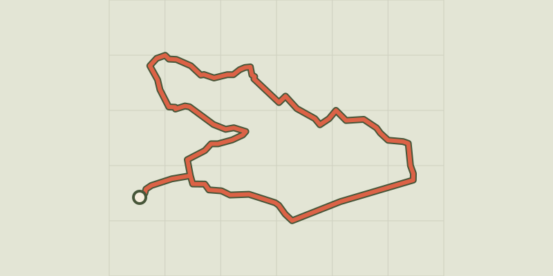
Key facts
- Distance
- 12.2 km
- Ascent
- +32 m
- Descent
- −6 m
- Estimated time
- 30 min
- road cycling
- Difficulty
- Very easy
- official rating
- Route
- Loop
- back to the start
Profile and gradient
- under 10%
- 10 to 20%
- over 20%
Gradient along the route: 12.2 km under 10%. Elevation from 91 m to 100 m over 12.2 km.
Description
Come crisscross Senas' little trails, at the mercy of the Provençal hedges and the cultures they hide ! "This walk is for you the opportunity to discover the nature side of Sénas as well as its agricultural character with its fruit fields : apple trees, peach trees, pear trees. You have a breathtaking view of the Luberon Massif. Along shady roubines, you may discover a herd of bulls. You can even improvise a picnic in a green area, all with your family. Good walk!" Sophie Mikelis, receptionist at the Tourist Information Office of Sénas. From the Tourist Office, take the avenue Jean Jaurès on the left to the town hall. Turn right on Avenue Désiré Pey and then on the left the passage Massart. 1- (Caution) continue on the avenue Louis Pascal. At the roundabout head straight under the motorway bridge, then turn immediately left on the path of Perrier Redon. Continue for 500 m. 2- Turn left on the path of the cabaret des Boeufs, direction la Peyronnette. Cross the stop and continue until the level crossing. 3- Take the Patis path on the right and immediately on your left the path of the Bressières Est area. Go up to the highway and turn right just after. 4- Go right at the next crossing. Continue on the path of Durancette and Dumaine. Take a right at the next intersection. 5- Turn left at the intersection and then right on the Bonfillons Sud road. Continue 200 m, before turning left onto the dirt road of the Crillons channel. 6- Turn left at the bridle with a house in the center and continue for 600m. After a large isolated pine tree, take the path on your left and continue to the road. 7- Take a right on the road to Mallemort, continue for 1 km. Turn right on chemin de l'Etang then continue on Chemin des Ribes and Brayettes. At the STOP turn left and return to the starting point.
Difficulty
Official rating: very easy, by Parcs naturels régionaux de Provence-Alpes-Côte d'Azur.
Before you go
- For your safety, and for the preservation of forest areas, access to natural areas is regulated from June to September. Inquire during the summer period on 08 11 20 13 13 (price of a local call) or on www.bouches-du-rhone.pref.gouv.fr Download the application for free MYPROVENCE ENVIE DE BALADE (available on Appstore and Android Market).
Getting there
Start: Office de Tourisme, Sénas, Sénas (13).
Sources
- Track: Parcs naturels régionaux de Provence-Alpes-Côte d'Azur (Chemins des Parcs), Licence Ouverte 2.0, Licence Ouverte 2.0 (Etalab) (www.cheminsdesparcs.fr/trek/58268-SENAS---Perrier-Redon-a-velo). Time estimated by GPX Path with the Mac app rule, breaks not included.
- Official elevation gain: 32 m, Parcs naturels régionaux de Provence-Alpes-Côte d'Azur
Nearby tracks

 © OpenStreetMap, SRTM · OpenTopoMap (CC-BY-SA)
Alpilles Roquemartine by bike: the variant of Orgon
Provence-Alpes-Côte d'Azur, Orgon (13) · LoopOfficial rating by Parcs naturels régionaux de Provence-Alpes-Côte d'Azur © OpenStreetMap, SRTM · OpenTopoMap (CC-BY-SA)
Robion - Du Calavon au Pays des Sorgues à vélo
Luberon, Robion (84) · LoopOfficial rating by Parcs naturels régionaux de Provence-Alpes-Côte d'Azur © OpenStreetMap, SRTM · OpenTopoMap (CC-BY-SA)
Perched villages by bike
Luberon, Maubec (84) · LoopOfficial rating by Parcs naturels régionaux de Provence-Alpes-Côte d'Azur © OpenStreetMap, SRTM · OpenTopoMap (CC-BY-SA)
The Alpilles Roquemartine by Bike: The Integral
Provence-Alpes-Côte d'Azur, Mouriès (13) · LoopOfficial rating by Parcs naturels régionaux de Provence-Alpes-Côte d'Azur © OpenStreetMap, SRTM · OpenTopoMap (CC-BY-SA)
Alpilles Roquemartine: The Mouriès loop
Provence-Alpes-Côte d'Azur, Mouriès (13) · LoopOfficial rating by Parcs naturels régionaux de Provence-Alpes-Côte d'Azur © OpenStreetMap, SRTM · OpenTopoMap (CC-BY-SA)
Saint-Rémy-de-Provence - Les jardins de Mistral à vélo
Provence-Alpes-Côte d'Azur, Saint-Rémy-de-Provence (13) · LoopOfficial rating by Parcs naturels régionaux de Provence-Alpes-Côte d'Azur