
The Cabre and The Pécoule
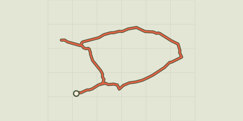
Key facts
- Distance
- 5.3 km
- Ascent
- +45 m
- Descent
- −12 m
- Estimated time
- 1 hr 10
- hiking
- Difficulty
- Easy
- official rating
- Route
- Loop
- back to the start
Profile and gradient
- under 10%
- 10 to 20%
- over 20%
Gradient along the route: 5.3 km under 10%. Elevation from 107 m to 129 m over 5.3 km.
Description
A little haven of peace, where nature lovers will be able to enjoy singing live birds in this preserved environment ! "The Pécoule hill is detached from the Alpilles massif like a tiny islet in the middle of the great Durance lowland. Between the discreet undulations of its relief carved small rocky bars, it houses small greenery rich in biodiversity that make up, with the edge of agricultural parcels, the main frame of this walk. " Virginie Brunet-Carbonero, Responsible for the management and enhancement of natural areas and their human activities in the Alpilles RNP From the car park, take the path between two metal poles. After the grove of pines, continue straight through the crossroads of tracks. 1- Follow the path on the right and join the intersection between the D71 (Alleins road) and the Chemin des Marmets. Take a left on this paved road and continue for 1 km to the houses. 2- Take the path on the left that passes between different buildings.. Once in the massif, stay on this track, leaving on the side all alternative paths. To arrive at the water tower, with its point of view on the Opies and the lowland of Roquemartine. 3- Turn around. 300 m further, stay to the right, then just after follow the path on the left. Continue for 700 m then at the crossroads after the house turn right and join the departure car park.
Difficulty
Official rating: easy, by Parcs naturels régionaux de Provence-Alpes-Côte d'Azur.
Before you go
- For your safety, and for the preservation of forest areas, access to natural areas is regulated from June to September. Inquire during the summer period on 08 11 20 13 13 (price of a local call) or on www.bouches-du-rhone.pref.gouv.fr Download the application for free MYPROVENCE ENVIE DE BALADE (available on Appstore and Android Market).
Getting there
Start: Parking du Parcours de santé, Sénas, Sénas (13).
Sources
- Track: Parcs naturels régionaux de Provence-Alpes-Côte d'Azur (Chemins des Parcs), Licence Ouverte 2.0, Licence Ouverte 2.0 (Etalab) (www.cheminsdesparcs.fr/trek/59299-SENAS---La-Cabre-et-la-Pecoule). Time estimated by GPX Path with the Mac app rule, breaks not included.
- Official elevation gain: 45 m, Parcs naturels régionaux de Provence-Alpes-Côte d'Azur
Nearby tracks

 © OpenStreetMap, SRTM · OpenTopoMap (CC-BY-SA)
Lamanon - Autour de Calès
Provence-Alpes-Côte d'Azur, Lamanon (13) · LoopOfficial rating by Parcs naturels régionaux de Provence-Alpes-Côte d'Azur © OpenStreetMap, SRTM · OpenTopoMap (CC-BY-SA)
Cheval-Blanc - Sentier du Trou du Rat par Mayorques
Luberon, Cheval-Blanc (84) · LoopOfficial rating by Parcs naturels régionaux de Provence-Alpes-Côte d'Azur © OpenStreetMap, SRTM · OpenTopoMap (CC-BY-SA)
Cheval-Blanc - De La Roquette à la crau des Mayorques
Luberon, Cheval-Blanc (84) · LoopOfficial rating by Parcs naturels régionaux de Provence-Alpes-Côte d'Azur © OpenStreetMap, SRTM · OpenTopoMap (CC-BY-SA)
Cheval-Blanc - Crau des Mayorques
Luberon, Cheval-Blanc (84) · LoopOfficial rating by Parcs naturels régionaux de Provence-Alpes-Côte d'Azur © OpenStreetMap, SRTM · OpenTopoMap (CC-BY-SA)
Vallon des Glauges
Provence-Alpes-Côte d'Azur, Eyguières (13) · LoopOfficial rating by Parcs naturels régionaux de Provence-Alpes-Côte d'Azur © OpenStreetMap, SRTM · OpenTopoMap (CC-BY-SA)
Mérindol - Sentier de l'observatoire
Luberon, Mérindol (84) · LoopOfficial rating by Parcs naturels régionaux de Provence-Alpes-Côte d'Azur