
The burnt farm
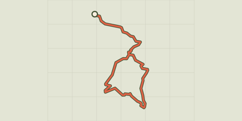
Key facts
- Distance
- 5.8 km
- Ascent
- +279 m
- Descent
- −259 m
- Estimated time
- 1 hr 50
- hiking
- Difficulty
- Moderate
- official rating
- Route
- Loop
- back to the start
Profile and gradient
- under 10%
- 10 to 20%
- over 20%
Gradient along the route: 3.5 km under 10%, 2.0 km at 10 to 20% and 0.3 km over 20%. Elevation from 1,140 m to 1,297 m over 5.8 km.
Description
A hike that will offer you a breathtaking view of Lake Castillon and Lake Chaudanne. Leave the village of Demandolx for a hike to discover the colorful landscapes of the Southern Alps. On the loop of the Burned Farm, you will pass not far from ruin and will join a pretty point of view on the lakes of Castillon, Chaudanne and on the surrounding mountains Exit the car park and follow the Avenue du Teillon towards Castellane then turn left, chemin de Thuveras. Go down the road on the right, continue straight on the farm path. At the end of the road at the place called La tour, continue in the same direction 1- At the intersection take the path on the right and go down to the creek. Cross the wooden bridge and go up the trail to an intersection. 2- Turn left towards GR®4 and Saint Barnabé. Go up the path and join an esplanade, under a high voltage line. Follow the trail (GR®4 red and white markings). 3- At the fork near the pylon turn right and descend for about 700 m until the track splits in two. 4- Leave the GR®4, and go down the track to the right. At the foot of the ruined farm, go up on the right by the path, passing over two terraces. Climb through the boxwood, up to "Cognas", an orientation table on a beautiful point of view. Then continue on the path below the table and join point 2 of the hike. Go down on the left and return to the village by the route taken on the way.
Difficulty
Official rating: moderate, by Parcs naturels régionaux de Provence-Alpes-Côte d'Azur.
Before you go
- avoid the hot summers, leave early.
- Allow 2 L of water per person, a hat and hiking shoes.
Getting there
Start: Chemin de Thuveras, Demandolx, Demandolx (04).
Sources
- Track: Parcs naturels régionaux de Provence-Alpes-Côte d'Azur (Chemins des Parcs), Licence Ouverte 2.0, Licence Ouverte 2.0 (Etalab) (www.cheminsdesparcs.fr/trek/54341-DEMANDOLX---La-Ferme-brulee). Time estimated by GPX Path with the Mac app rule, breaks not included.
- Official elevation gain: 279 m, Parcs naturels régionaux de Provence-Alpes-Côte d'Azur
Nearby tracks

 © OpenStreetMap, SRTM · OpenTopoMap (CC-BY-SA)
The summit of Teillon
Verdon, La Garde (04) · Out and backOfficial rating by Parcs naturels régionaux de Provence-Alpes-Côte d'Azur © OpenStreetMap, SRTM · OpenTopoMap (CC-BY-SA)
The peak of Mount Crémon
Verdon, Saint-Julien-du-Verdon (04) · Out and backOfficial rating by Parcs naturels régionaux de Provence-Alpes-Côte d'Azur © OpenStreetMap, SRTM · OpenTopoMap (CC-BY-SA)
The summit of Destourbes
Verdon, Castellane (04) · Out and backOfficial rating by Parcs naturels régionaux de Provence-Alpes-Côte d'Azur © OpenStreetMap, SRTM · OpenTopoMap (CC-BY-SA)
The Tour of Défens des Colettes
Verdon, Soleilhas (04) · LoopOfficial rating by Parcs naturels régionaux de Provence-Alpes-Côte d'Azur © OpenStreetMap, SRTM · OpenTopoMap (CC-BY-SA)
Barre du Pidanoux
Verdon, Saint-Julien-du-Verdon (04) · Out and backOfficial rating by Parcs naturels régionaux de Provence-Alpes-Côte d'Azur © OpenStreetMap, SRTM · OpenTopoMap (CC-BY-SA)
Tour du Roc
Verdon, Castellane (04) · LoopOfficial rating by Parcs naturels régionaux de Provence-Alpes-Côte d'Azur