
The Tour of Défens des Colettes
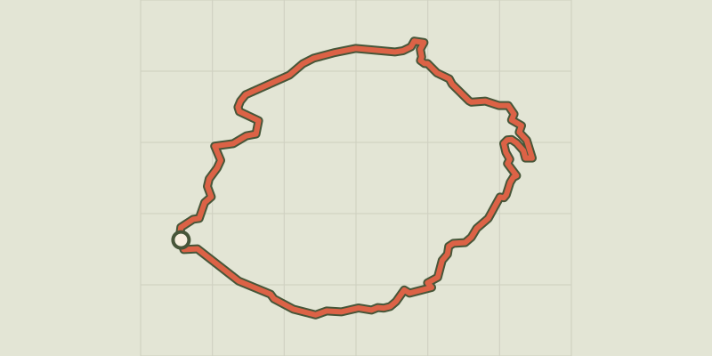
Key facts
- Distance
- 8.3 km
- Ascent
- +438 m
- Descent
- −396 m
- Estimated time
- 2 hr 40
- hiking
- Difficulty
- Moderate
- official rating
- Route
- Loop
- back to the start
Profile and gradient
- under 10%
- 10 to 20%
- over 20%
Gradient along the route: 4.7 km under 10%, 2.7 km at 10 to 20% and 0.8 km over 20%. Elevation from 1,086 m to 1,355 m over 8.3 km.
Description
On the trail of the Tour of Défens des Colettes, you will reach old plasterwork remains of a craft no longer practised, near the travertin waterfalls. Explore Soleilhas, its fountains and wash houses take the GR 4 to rise to Mount Saint-Foujasse. You will reach old plasterwork remains of a craft no longer practised, near the travertin waterfalls. The return trip to the village is through a path lined with chapels that emphasize the pilgrimage to Saint-Peter's chapel. When exiting the car park, turn right and at the end of the street, take another right and follow the main street Saint Roch on the D102 for some hundred metres. 1 - Before the mission cross, turn right on the variant of the GR 4 (chemin de la sagne) then cross a bridge and a field. At the first corner, take the GR and follow the track to switch to the other side. Continue on the path between meadows and woods of Scots pines and continue rising amid the broom on the opposite slope. Continue until an intersection. 2 - Take a right on the GR.. Further down, descend on the trail of the ruins of Veraillon. 3 - Under the ruins, turn right, in the meadow and along the creek. Go left, over the canyon (area wedged between two mountains). Go down through the pubescent oak (900m). 4 - At the intersection of two paths, continue straight and follow the path through the rocks, then head to the St. Peter Chapel. 5 - From the St. Peter chapel, follow the direction of Soleilhas (under the chapel). 20m before the waterfall, turn right onto the rocky and steep path rising above the canyon. Pass the ford at 100m and reach to Soleilhas. At 2.5km, reach the trail. 6 - Turn right in front of the oratory and reach the village by the track.
Difficulty
Official rating: moderate, by Parcs naturels régionaux de Provence-Alpes-Côte d'Azur.
Before you go
- Avoid high summer temperatures, leave early. We recommend: 2 L of water per person, a hat and proper hiking shoes. At some points of the route, the trek can be quite technical, especially in the canyon.
Getting there
Start: Rue Saint Roch, Soleilhas, Soleilhas (04).
Sources
- Track: Parcs naturels régionaux de Provence-Alpes-Côte d'Azur (Chemins des Parcs), Licence Ouverte 2.0, Licence Ouverte 2.0 (Etalab) (www.cheminsdesparcs.fr/trek/19829-SOLEILHAS---Le-Defens-des-Colettes). Time estimated by GPX Path with the Mac app rule, breaks not included.
- Official elevation gain: 438 m, Parcs naturels régionaux de Provence-Alpes-Côte d'Azur
Nearby tracks

 © OpenStreetMap, SRTM · OpenTopoMap (CC-BY-SA)
A round-trip to Peyroules
Verdon, Peyroules (04) · LoopOfficial rating by Parcs naturels régionaux de Provence-Alpes-Côte d'Azur © OpenStreetMap, SRTM · OpenTopoMap (CC-BY-SA)
The burnt farm
Verdon, Demandolx (04) · LoopOfficial rating by Parcs naturels régionaux de Provence-Alpes-Côte d'Azur © OpenStreetMap, SRTM · OpenTopoMap (CC-BY-SA)
The summit of Teillon
Verdon, La Garde (04) · Out and backOfficial rating by Parcs naturels régionaux de Provence-Alpes-Côte d'Azur © OpenStreetMap, SRTM · OpenTopoMap (CC-BY-SA)
Tour de l'Artuby - 5 par Le Logis du Pin
Verdon, La Martre (83) · Point to pointOfficial rating by Parcs naturels régionaux de Provence-Alpes-Côte d'Azur © OpenStreetMap, SRTM · OpenTopoMap (CC-BY-SA)
Le chemin de Napoléon
Verdon, La Martre (83) · Out and backOfficial rating by Parcs naturels régionaux de Provence-Alpes-Côte d'Azur © OpenStreetMap, SRTM · OpenTopoMap (CC-BY-SA)
The peak of Mount Crémon
Verdon, Saint-Julien-du-Verdon (04) · Out and backOfficial rating by Parcs naturels régionaux de Provence-Alpes-Côte d'Azur