
The cave path

Key facts
- Distance
- 2.1 km
- Ascent
- +65 m
- Descent
- −57 m
- Estimated time
- 35 min
- hiking
- Difficulty
- Very easy
- official rating
- Route
- Loop
- back to the start
Profile and gradient
- under 10%
- 10 to 20%
- over 20%
Gradient along the route: 1.7 km under 10% and 0.4 km at 10 to 20%. Elevation from 495 m to 559 m over 2.1 km.
Description
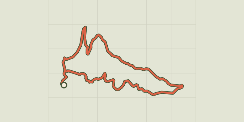
A beautiful walk through various landscapes, the olive trees, the stone walls, the caves and especially the rupestrian chapels. A walk that begins in the streets of the village where you have to know how to raise your head to see a lot of heritage wealth. Continuing your walk beyond the ramparts, you will pass under the St Trinité chapel, do not hesitate to visit his tenant, he always has a story to tell. Then you will discover the rocks of Sainte-Marie-Magdeleine and its chapel located in a cave, the oil mill, olive groves, dry stone walls. From the tourist office, pass the St-Pancrace church and walk up Aups through the medieval streets (attention, the yellow markings begins at point (1). Pass at the foot of the Tour de l'Horloge, follow the Aires street and exit the ramparts through the Aires portal. Walk along the Notre-Dame de la Délivrance chapel and enter the Devensaux rural road on the other side of the road. 1- At 150 m, leave the small road and turn right on chemin de la Trinité. Pass the college, the dirt road is tarred. Climb up to the chapel Sainte-Trinité (10th and 11th centuries), pass below, and join a dirt road to the first caves of Aups. Continue on the flat road for another 300 m to reach, nestled in the wall, the curious Sainte-Magdeleine chapel. Continue the route under the green oaks, walk along a low wall and join the intersection with the Croix des Pins path 2- Follow the path on the right and go down along dry stone walls. Join a small road, continue to descend, pass the buildings of the oil mill and get to the departmental road from Aups to Tourtour. Go back through the Charles Boyer alley to the village.
Difficulty
Official rating: very easy, by Parcs naturels régionaux de Provence-Alpes-Côte d'Azur.
Before you go
- Provide 1L of water per person, a hat and walking shoes. Consult the fire risk map in the "find out more" link during the summer period from 15 June - 15 September. Preferred seasons : All.
Getting there
Start: Devant l'office de tourisme, Aups (83).
Sources
- Track: Parcs naturels régionaux de Provence-Alpes-Côte d'Azur (Chemins des Parcs), Licence Ouverte 2.0, Licence Ouverte 2.0 (Etalab) (www.cheminsdesparcs.fr/trek/65292-AUPS---Le-sentier-des-grottes). Time estimated by GPX Path with the Mac app rule, breaks not included.
- Official elevation gain: 65 m, Parcs naturels régionaux de Provence-Alpes-Côte d'Azur
Nearby tracks
 © OpenStreetMap, SRTM · OpenTopoMap (CC-BY-SA)
La Croix des Pins
Verdon, Aups (83) · LoopOfficial rating by Parcs naturels régionaux de Provence-Alpes-Côte d'Azur © OpenStreetMap, SRTM · OpenTopoMap (CC-BY-SA)
The Notre-Dame de Liesse Chapel
Verdon, Aups (83) · LoopOfficial rating by Parcs naturels régionaux de Provence-Alpes-Côte d'Azur © OpenStreetMap, SRTM · OpenTopoMap (CC-BY-SA)
The Plain (forest)
Verdon, Moissac-Bellevue (83) · LoopOfficial rating by Parcs naturels régionaux de Provence-Alpes-Côte d'Azur © OpenStreetMap, SRTM · OpenTopoMap (CC-BY-SA)
The Pelenc forest from Moissac Bellevue
Verdon, Moissac-Bellevue (83) · LoopOfficial rating by Parcs naturels régionaux de Provence-Alpes-Côte d'Azur © OpenStreetMap, SRTM · OpenTopoMap (CC-BY-SA)
The Pelenc forest from Régusse
Verdon, Régusse (83) · LoopOfficial rating by Parcs naturels régionaux de Provence-Alpes-Côte d'Azur © OpenStreetMap, SRTM · OpenTopoMap (CC-BY-SA)
La Colle (hill)
Verdon, Régusse (83) · LoopOfficial rating by Parcs naturels régionaux de Provence-Alpes-Côte d'Azur