
The Grande Traversée des Hautes-Alpes (GTHA)
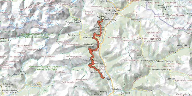
Key facts
- Distance
- 51.9 km
- Ascent
- +2,231 m
- Descent
- −2,795 m
- Estimated time
- 7 hr 55
- mtb
- Difficulty
- Difficult
- official rating
- Route
- Point to point
- ends elsewhere
Profile and gradient
- under 10%
- 10 to 20%
- over 20%
Gradient along the route: 33.0 km under 10%, 16.0 km at 10 to 20% and 2.9 km over 20%. Elevation from 1,028 m to 1,931 m over 51.9 km.
Description
A sensational circuit which crosses the territory of the Pays des Écrins from north to south. The GTHA is the highest medium-altitude mountain bike route in France. It starts in La Grave-Villar d'Arène and ends in Laragne-Montéglin, thus taking you through 50 kilometres of the territory of the Pays des Écrins. Along the way you will get to know the territory and its communities through its remarkable landscapes and heritage. So, all you need to do is jump on your bike and set off on the adventure. For more information on the GTHA itinerary, visit the Département des Hautes-Alpes website .
Difficulty
Official rating: difficult, by Parc national des Écrins.
Before you go
- Rescue services contact details: Secours Montagne (Mountain Rescue): +33 (0)4 92 22 22 22 or 112
- Show consideration for the work of farmers, livestock keepers and owners
- Close all gates behind you
- Take your litter home
- Do not take shortcuts across pastureland
Getting there
Start: Rocher de Roure, Puy-Saint-André, Saint-Martin-de-Queyrières (05).
Sources
- Track: Parc national des Écrins, Licence Ouverte 2.0, Licence Ouverte 2.0 (Etalab) (destination.ecrins-parcnational.fr/trek/973511-La-Grande-Traversee-des-Hautes-Alpes-(GTHA)-sur-le-territoire-du-Pays-des-Ecrins). Time estimated by GPX Path with the Mac app rule, breaks not included.
- Official elevation gain: 2,231 m, Parc national des Écrins
Nearby tracks

 Plan IGN © IGN 2026Traversée du Pays des Ecrins en VTT en 2 joursÉcrins, Briançon (05) · Point to pointOfficial rating by Parc national des Écrins
 Plan IGN © IGN 2026Les Choulières circuit (no. 3)Écrins, Vallouise-Pelvoux (05) · LoopOfficial rating by Parc national des Écrins
 Plan IGN © IGN 2026Les Claux circuit (no. 4)Écrins, Vallouise-Pelvoux (05) · LoopOfficial rating by Parc national des Écrins
 Plan IGN © IGN 2026Le Grand Parcher circuit (no. 6)Écrins, Les Vigneaux (05) · LoopOfficial rating by Parc national des Écrins
 Plan IGN © IGN 2026Le Bois des GuibertesÉcrins, La Salle-les-Alpes (05) · LoopOfficial rating by Parc national des Écrins
 Plan IGN © IGN 2026The Onde circuit (no. 5)Écrins, Vallouise-Pelvoux (05) · LoopOfficial rating by Parc national des Écrins