
Le Piolit vertical kilometre
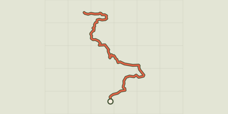
Key facts
- Distance
- 13.5 km
- Ascent
- +1,029 m
- Descent
- −1,004 m
- Estimated time
- 2 hr 20
- trail running
- Difficulty
- Moderate
- official rating
- Route
- Out and back
- same way back
Profile and gradient
- under 10%
- 10 to 20%
- over 20%
Gradient along the route: 5.4 km under 10%, 4.7 km at 10 to 20% and 3.4 km over 20%. Elevation from 1,462 m to 2,433 m over 13.5 km.
Description
A sporty route through the colourful mountain pastures leading to Le Piolit. Le Piolit, the region's iconic peak, rewards the effort, with its steep gradients. This very bucolic atmosphere is followed by a more mineral landscape which marks the end of the efforts and gradually reveals a more distant horizon from which emerge the first 3000m of the Ecrins to the north and the lake of Serre-Ponçon to the south. 1. First follow the track via the yellow markings, then leave the track for a small path on the right. Cross the track and stay on it until you reach the crossroads. Go straight ahead past the houses. Turn left towards a farm then continue uphill past a second house. 2. When you reach the track, keep right until you reach the end. Then take a path on the left that leads around a cow pasture. Turn left down the path. 3. Cross a stream and shortly after turn right onto a small path. Continue straight on at the next intersection. Turn right into the hollow of a valley and continue on a track that disappears under the grass 200m higher up. 4. Then go along a ravine. Then climb up along a scree (yellow stakes and cairns). Follow the cairns in the pastures and then cross a new scree slope. There is one scree slope after another as far as the Col de Chorges. 5. Turn left to reach the summit of Piolit, the final section is very steep and more rugged. 6. The return journey takes the same route.
Difficulty
Official rating: moderate, by Parc national des Écrins.
Getting there
Start: Hameau de Naune Raze, Chorges (05).
Sources
- Track: Parc national des Écrins, Licence Ouverte 2.0, Licence Ouverte 2.0 (Etalab) (destination.ecrins-parcnational.fr/trek/995596-Kilometre-vertical-du-Piolit). Time estimated by GPX Path with the Mac app rule, breaks not included.
- Official elevation gain: 1,029 m, Parc national des Écrins
Nearby tracks

 © OpenStreetMap, SRTM · OpenTopoMap (CC-BY-SA)
Le petit bois
Provence-Alpes-Côte d'Azur, Chorges (05) · LoopOfficial rating by Parc national des Écrins © OpenStreetMap, SRTM · OpenTopoMap (CC-BY-SA)
The banks of the lake
Provence-Alpes-Côte d'Azur, Chorges (05) · LoopOfficial rating by Parc national des Écrins © OpenStreetMap, SRTM · OpenTopoMap (CC-BY-SA)
The chalets of Vaucluse
Écrins, Réallon (05) · LoopOfficial rating by Parc national des Écrins © OpenStreetMap, SRTM · OpenTopoMap (CC-BY-SA)
Saint-Apollinaire lake
Écrins, Réallon (05) · LoopOfficial rating by Parc national des Écrins © OpenStreetMap, SRTM · OpenTopoMap (CC-BY-SA)
Aiguilles de Chabrières
Écrins, Réallon (05) · LoopOfficial rating by Parc national des Écrins © OpenStreetMap, SRTM · OpenTopoMap (CC-BY-SA)
Pierre-Arnoux
Écrins, Savines-le-Lac (05) · LoopOfficial rating by Parc national des Écrins